
Thank you for supporting this site ❤️
Make a donation
Make a donation
Temburong District topographic map
Click on the map to display elevation.
Thank you for supporting this site ❤️
Make a donation
Make a donation
About this map
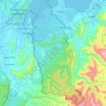
Name: Temburong District topographic map, elevation, terrain.
Location: Temburong District, Brunei (4.29621 115.02203 4.96222 115.36356)
Average elevation: 229 m
Minimum elevation: -4 m
Maximum elevation: 1,691 m
Thank you for supporting this site ❤️
Make a donation
Make a donation
Other topographic maps
Click on a map to view its topography, its elevation and its terrain.
Thank you for supporting this site ❤️
Make a donation
Make a donation
Thank you for supporting this site ❤️
Make a donation
Make a donation
Thank you for supporting this site ❤️
Make a donation
Make a donation
Thank you for supporting this site ❤️
Make a donation
Make a donation
Thank you for supporting this site ❤️
Make a donation
Make a donation
Thank you for supporting this site ❤️
Make a donation
Make a donation