
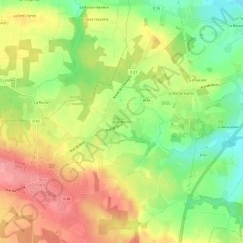
Bois Martin topographic map
Interactive map
Click on the map to display elevation.
About this map
Name: Bois Martin topographic map, elevation, terrain.
Average elevation: 65 m
Minimum elevation: 18 m
Maximum elevation: 108 m
Other topographic maps
Click on a map to view its topography, its elevation and its terrain.
La Roche Martin
France > Bretagne > Ille-et-Vilaine > Goven
La Roche Martin, Goven, Redon, Ille-et-Vilaine, Bretagne, France métropolitaine, 35580, France
Average elevation: 49 m
Château de Blossac
France > Bretagne > Ille-et-Vilaine > Goven > Blossac
Château de Blossac, Accès du Château, Blossac, Goven, Redon, Ille-et-Vilaine, Bretagne, France métropolitaine, 35580, France
Average elevation: 25 m