Geolocate

博美镇 topographic map

Interactive map

Click on the map to display elevation.

About this map

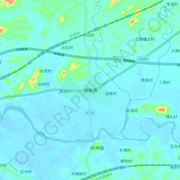
Name: 博美镇 topographic map, elevation, terrain.

Location: 博美镇, 陆丰市, 汕尾市, 广东省, 中国 (22.90889 115.74096 22.98889 115.82096)

Average elevation: 9 m

Minimum elevation: -4 m

Maximum elevation: 80 m

Other topographic maps

Click on a map to view its topography, its elevation and its terrain.

西美村

中国 > 广东省 > 陆丰市

西美村, 陆丰市, 汕尾市, 广东省, 中国

Average elevation: 10 m

碣石镇

中国 > 广东省 > 陆丰市

碣石镇, 陆丰市, 汕尾市, 广东省, 516545, 中国

Average elevation: 19 m

潭西镇

中国 > 广东省 > 陆丰市

潭西镇, 陆丰市, 汕尾市, 广东省, 中国

Average elevation: 13 m

洋溢

中国 > 广东省 > 陆丰市

洋溢, 陆丰市, 汕尾市, 广东省, 中国

Average elevation: 49 m

陆丰市

中国 > 广东省 > 陆丰市

陆丰市, 汕尾市, 广东省, 516500, 中国

Average elevation: 50 m