
Adamawa State topographic map
Interactive map
Click on the map to display elevation.
Adamawa State
Topographically, it is a mountainous land crossed by the large river valleys – Benue, Gongola and Yedsarem. The valleys of the Mount Cameroon, Mandara Mountains and Adamawa Plateau form part of the landscape.
About this map
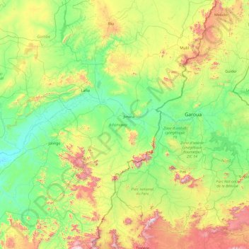
Name: Adamawa State topographic map, elevation, terrain.
Location: Adamawa State, Nigeria (7.35837 11.34152 10.94946 13.72955)
Average elevation: 452 m
Minimum elevation: 105 m
Maximum elevation: 1,949 m
Other topographic maps
Click on a map to view its topography, its elevation and its terrain.