
Thank you for supporting this site ❤️
Make a donation
Make a donation
Forlì-Cesena topographic map
Click on the map to display elevation.
Thank you for supporting this site ❤️
Make a donation
Make a donation
About this map
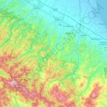
Name: Forlì-Cesena topographic map, elevation, terrain.
Location: Forlì-Cesena, Emilia-Romagna, Italy (43.74054 11.64555 44.33068 12.45778)
Average elevation: 399 m
Minimum elevation: -6 m
Maximum elevation: 1,638 m
Thank you for supporting this site ❤️
Make a donation
Make a donation
Other topographic maps
Click on a map to view its topography, its elevation and its terrain.
Thank you for supporting this site ❤️
Make a donation
Make a donation
Bologna
Italy > Emilia-Romagna > Bologna > Bologna
Bologna is situated on the edge of the Po Plain at the foot of the Apennine Mountains, at the meeting of the Reno and Savena river valleys. As Bologna's two main watercourses flow directly to the sea, the town lies outside of the drainage basin of the River Po. The Province of Bologna stretches from the…
Average elevation: 118 m