
Wallburg topographic map
Interactive map
Click on the map to display elevation.
About this map
Name: Wallburg topographic map, elevation, terrain.
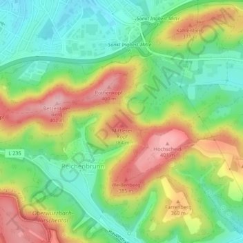
Average elevation: 309 m
Minimum elevation: 235 m
Maximum elevation: 407 m
Von der naturräumlichen Gliederung her liegt St. Ingbert (Kernstadt und Rohrbach) im Bereich der St. Ingberter Senke, die den westlichen Abschluss der St. Ingbert-Kaiserslauterer Senke bildet. Die Ortschaften Hassel, Oberwürzbach, Reichenbrunn und Sengscheid gehören zum Sankt Ingbert-Kirkeler Waldgebiet. Dieses endet mit dem Höhenzug Kahlenberg – Betzentaler Berg (Rotenkopf) – Stiefel, der gegen die Senke hin steil abbricht.
Other topographic maps
Click on a map to view its topography, its elevation and its terrain.
Oberwürzbach
Deutschland > Saarland > Saarpfalz-Kreis > St. Ingbert
Oberwürzbach, St. Ingbert, Saarpfalz-Kreis, Saarland, Deutschland
Average elevation: 314 m