
Thank you for supporting this site ❤️
Make a donation
Make a donation
Jonesboro topographic map
Click on the map to display elevation.
Thank you for supporting this site ❤️
Make a donation
Make a donation
About this map
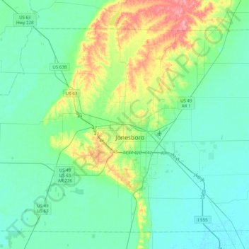
Name: Jonesboro topographic map, elevation, terrain.
Location: Jonesboro, Craighead County, Arkansas, 72401, United States (35.68286 -90.86345 36.00286 -90.54345)
Average elevation: 87 m
Minimum elevation: 66 m
Maximum elevation: 160 m
Thank you for supporting this site ❤️
Make a donation
Make a donation