
Cerro de la Encinilla topographic map
Interactive map
Click on the map to display elevation.
About this map
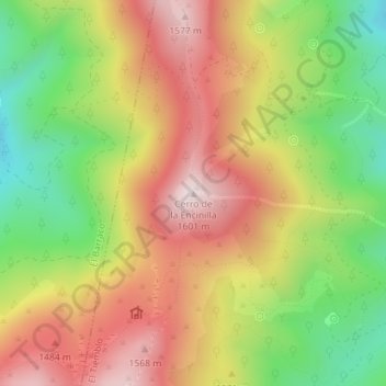
Name: Cerro de la Encinilla topographic map, elevation, terrain.
Average elevation: 1,333 m
Minimum elevation: 1,054 m
Maximum elevation: 1,596 m
Other topographic maps
Click on a map to view its topography, its elevation and its terrain.
Embalse de El Burguillo
España > Castilla y León > El Tiemblo > Poblado de Burguillo
Embalse de El Burguillo, Carretera de Ávila a Toledo, Poblado de Burguillo, El Tiemblo, Valle del Alberche, Ávila, Castilla y León, 45213, España
Average elevation: 940 m
Alberche
España > Castilla y León > El Tiemblo
Alberche, El Tiemblo, Castilla y León, 45213, España
Average elevation: 809 m