
Thank you for supporting this site ❤️
Make a donation
Make a donation
Térmens topographic map
Click on the map to display elevation.
Thank you for supporting this site ❤️
Make a donation
Make a donation
Térmens
Térmens liegt etwa 22 Kilometer nordöstlich von Lleida und östlich des Flusses Segre in einer Höhe von ca. 210 m.
Thank you for supporting this site ❤️
Make a donation
Make a donation
About this map
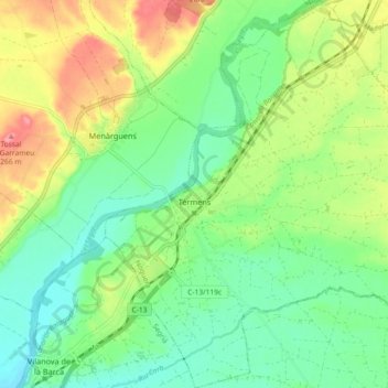
Name: Térmens topographic map, elevation, terrain.
Location: Térmens, Noguera, Lleida, Katalonien, 25670, Spanien (41.68572 0.74203 41.75388 0.83141)
Average elevation: 207 m
Minimum elevation: 173 m
Maximum elevation: 264 m
Thank you for supporting this site ❤️
Make a donation
Make a donation
Other topographic maps
Click on a map to view its topography, its elevation and its terrain.