
Goguelais topographic map
Interactive map
Click on the map to display elevation.
About this map
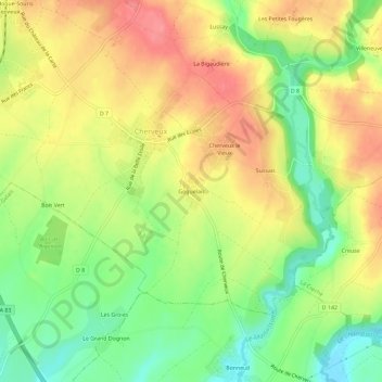
Name: Goguelais topographic map, elevation, terrain.
Average elevation: 81 m
Minimum elevation: 40 m
Maximum elevation: 119 m
Other topographic maps
Click on a map to view its topography, its elevation and its terrain.
Château de Cherveux
France > Nouvelle-Aquitaine > Deux-Sèvres > Cherveux > Goguelais
Château de Cherveux, Rue des Douves, Goguelais, Cherveux, Niort, Deux-Sèvres, Nouvelle-Aquitaine, France métropolitaine, 79410, France
Average elevation: 91 m