
Thank you for supporting this site ❤️
Make a donation
Make a donation
Pentyrch topographic map
Click on the map to display elevation.
Thank you for supporting this site ❤️
Make a donation
Make a donation
About this map
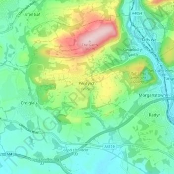
Name: Pentyrch topographic map, elevation, terrain.
Location: Pentyrch, Cardiff, Wales, CF, United Kingdom (51.50622 -3.34377 51.55186 -3.25733)
Average elevation: 99 m
Minimum elevation: 20 m
Maximum elevation: 303 m
Thank you for supporting this site ❤️
Make a donation
Make a donation
Other topographic maps
Click on a map to view its topography, its elevation and its terrain.