Geolocate

Jerome County topographic map

Interactive map

Click on the map to display elevation.

About this map

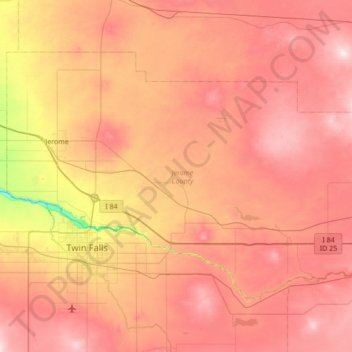
Name: Jerome County topographic map, elevation, terrain.

Location: Jerome County, Idaho, United States (42.49773 -114.61700 42.85135 -113.93082)

Average elevation: 1,225 m

Minimum elevation: 912 m

Maximum elevation: 1,452 m

Other topographic maps

Click on a map to view its topography, its elevation and its terrain.

Lewiston

United States > Idaho > Nez Perce County

According to the U.S. Census Bureau, the city has a total area of 18.04 square miles (46.72 km2), of which 17.23 square miles (44.63 km2) is land and 0.81 square miles (2.10 km2) is water. Downtown Lewiston, at elevations between 740 feet (230 m) and 780 feet (240 m), is only slightly higher in elevation than…

Average elevation: 334 m