
Mariadorp topographic map
Interactive map
Click on the map to display elevation.
About this map
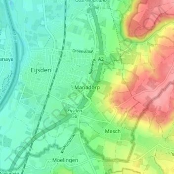
Name: Mariadorp topographic map, elevation, terrain.
Average elevation: 75 m
Minimum elevation: 41 m
Maximum elevation: 138 m
Other topographic maps
Click on a map to view its topography, its elevation and its terrain.
Hoog-Caestert
Nederland > Limburg > Eijsden > Mariadorp > Hoog-Caestert
Hoog-Caestert, Mariadorp, Eijsden, Eijsden-Margraten, Limburg, Nederland, 6245 AK, Nederland
Average elevation: 65 m
Oost-Maarland
Oost-Maarland, Eijsden, Eijsden-Margraten, Limburg, Nederland, 6245 LH, Nederland
Average elevation: 64 m