
Thank you for supporting this site ❤️
Make a donation
Make a donation
Neckarhalde topographic map
Click on the map to display elevation.
Thank you for supporting this site ❤️
Make a donation
Make a donation
About this map
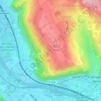
Name: Neckarhalde topographic map, elevation, terrain.
Average elevation: 300 m
Minimum elevation: 226 m
Maximum elevation: 421 m
Thank you for supporting this site ❤️
Make a donation
Make a donation
Other topographic maps
Click on a map to view its topography, its elevation and its terrain.
Jägerhaus
Deutschland > Baden-Württemberg > Landkreis Esslingen > Esslingen am Neckar
Average elevation: 415 m
Kimmichsweiler
Deutschland > Baden-Württemberg > Landkreis Esslingen > Esslingen am Neckar
Average elevation: 353 m