
Thank you for supporting this site ❤️
Make a donation
Make a donation
Hallstead topographic map
Click on the map to display elevation.
Thank you for supporting this site ❤️
Make a donation
Make a donation
About this map
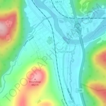
Name: Hallstead topographic map, elevation, terrain.
Location: Hallstead, Susquehanna County, Pennsylvania, United States (41.95139 -75.75442 41.97033 -75.74154)
Average elevation: 323 m
Minimum elevation: 256 m
Maximum elevation: 494 m
Thank you for supporting this site ❤️
Make a donation
Make a donation
Other topographic maps
Click on a map to view its topography, its elevation and its terrain.
Heart Lake
United States > Pennsylvania > Susquehanna County > Bridgewater Township
Average elevation: 482 m
Thank you for supporting this site ❤️
Make a donation
Make a donation
Lake Erie
United States > Pennsylvania > Susquehanna County > Clifford Township
Average elevation: 517 m
Thank you for supporting this site ❤️
Make a donation
Make a donation
Thank you for supporting this site ❤️
Make a donation
Make a donation