
Make a donation
Hanover topographic map
Click on the map to display elevation.
Make a donation
Hanover
In 1636 George, Duke of Brunswick-Lüneburg, ruler of the Brunswick-Lüneburg principality of Calenberg, moved his residence to Hanover. The Dukes of Brunswick-Lüneburg were elevated by the Holy Roman Emperor to the rank of Prince-Elector in 1692 and this elevation was confirmed by the Imperial Diet in 1708. Thus the principality was upgraded to the Electorate of Brunswick-Lüneburg, colloquially known as the Electorate of Hanover after Calenberg's capital (see also: House of Hanover). Its Electors later become monarchs of Great Britain (and from 1801 of the United Kingdom of Great Britain and Ireland). The first of these was George I Louis, who acceded to the British throne in 1714. The last British monarch who reigned in Hanover was William IV. Semi-Salic law, which required succession by the male line if possible, forbade the accession of Queen Victoria in Hanover. As a male-line descendant of George I, Queen Victoria was herself a member of the House of Hanover. Her descendants, however, bore her husband's titular name of Saxe-Coburg-Gotha. Three kings of Great Britain, or the United Kingdom, were concurrently also Electoral Princes of Hanover.
Make a donation
About this map
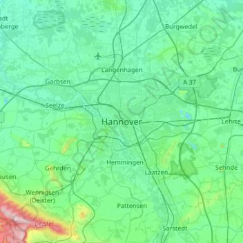
Name: Hanover topographic map, elevation, terrain.
Location: Hanover, Region Hannover, Lower Saxony, 30159, Germany (52.21448 9.57855 52.53448 9.89855)
Average elevation: 70 m
Minimum elevation: 22 m
Maximum elevation: 402 m
Make a donation
Other topographic maps
Click on a map to view its topography, its elevation and its terrain.