
Thank you for supporting this site ❤️
Make a donation
Make a donation
Larbaa topographic map
Click on the map to display elevation.
Thank you for supporting this site ❤️
Make a donation
Make a donation
About this map
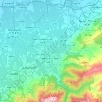
Name: Larbaa topographic map, elevation, terrain.
Location: Larbaa, Larbaa District, Blida, 09300, Algeria (36.50309 3.11138 36.65347 3.23635)
Average elevation: 197 m
Minimum elevation: 19 m
Maximum elevation: 1,012 m
Thank you for supporting this site ❤️
Make a donation
Make a donation