
Thank you for supporting this site ❤️
Make a donation
Make a donation
San Martin topographic map
Click on the map to display elevation.
Thank you for supporting this site ❤️
Make a donation
Make a donation
About this map
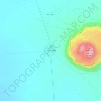
Name: San Martin topographic map, elevation, terrain.
Average elevation: 3,723 m
Minimum elevation: 3,673 m
Maximum elevation: 3,981 m
Thank you for supporting this site ❤️
Make a donation
Make a donation
Other topographic maps
Click on a map to view its topography, its elevation and its terrain.
Salinas de Garci Mendoza
Bolivia > Oruro > Ladislao Cabrera > Salinas de Garcí Mendoza
Average elevation: 3,815 m