
Saint-Jacques topographic map
Interactive map
Click on the map to display elevation.
About this map
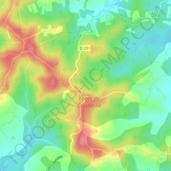
Name: Saint-Jacques topographic map, elevation, terrain.
Average elevation: 78 m
Minimum elevation: 38 m
Maximum elevation: 136 m
Other topographic maps
Click on a map to view its topography, its elevation and its terrain.
Laplacote
France > Nouvelle-Aquitaine > Cauneille > Laplacote
Laplacote, Cauneille, Dax, Landes, Nouvelle-Aquitaine, France métropolitaine, 40300, France
Average elevation: 34 m