
Les Garroustes topographic map
Interactive map
Click on the map to display elevation.
About this map
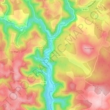
Name: Les Garroustes topographic map, elevation, terrain.
Average elevation: 278 m
Minimum elevation: 150 m
Maximum elevation: 368 m
Other topographic maps
Click on a map to view its topography, its elevation and its terrain.
Moulin de Guillot
France > Occitanie > Lot > Cabrerets > Moulin de Guillot
Moulin de Guillot, Cabrerets, Cahors, Lot, Occitanie, France métropolitaine, 46330, France
Average elevation: 275 m
Prat d'Algan
France > Occitanie > Lot > Cabrerets
Prat d'Algan, Cabrerets, Cahors, Lot, Occitanie, France métropolitaine, 46330, France
Average elevation: 287 m