
Make a donation
North Sulawesi topographic map
Click on the map to display elevation.
Make a donation
North Sulawesi
The province's capital and largest city is Manado, which is also the main gateway and the economic center of the province. Other major towns includes Tomohon and Bitung in the northern (Minahasa) half of the province, and Kotamobagu in the southern (Bolaang Mongondow) half. There are 41 mountains with an altitude ranging from 1,112–1,995 metres (3,648–6,545 ft). Most geologic conditions in the province are consisted mainly of young volcanic regions, with numerous eruptions and many active volcanic cones that adorn the central Minahasa, Bolaang Mongondow and Sangihe Islands.
Make a donation
About this map
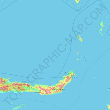
Name: North Sulawesi topographic map, elevation, terrain.
Location: North Sulawesi, Sulawesi, Indonesia (-0.55341 123.09631 5.76395 127.75400)
Average elevation: 28 m
Minimum elevation: 0 m
Maximum elevation: 2,063 m
Make a donation
Other topographic maps
Click on a map to view its topography, its elevation and its terrain.
Make a donation
Make a donation
Make a donation
Make a donation
Make a donation
Make a donation
Make a donation
Rinjani
Indonesia > West Nusa Tenggara
In September 1995 an aviation report was issued concerning an unconfirmed ash cloud from Rinjani. A NOTAM about volcanic activity from Rinjani was issued by the Bali Flight Information Region on the morning of 12 September. An ash cloud was reportedly drifting to the south west with the cloud top around 4 km…
Average elevation: 3,071 m
Make a donation
Make a donation
Make a donation
Make a donation
Non Block High Level Conference Monument Park
Indonesia > West Java > Bandung City > Arjuna
Average elevation: 731 m
Make a donation
Puncak Jaya
Indonesia > Central Papua > Mimika
Puncak Jaya (Indonesian: [ˈpuntʃak ˈdʒaja]; literally "Victorious Peak", Amungme: Nemangkawi Ninggok) or Carstensz Pyramid (/ˈkɑːrstəns/, Indonesian: Piramida Carstensz, Dutch: Carstenszpiramide) on the island of New Guinea, with an elevation of 4,884 m (16,024 ft), is the highest mountain peak of an…
Average elevation: 4,271 m
Make a donation
Make a donation
Make a donation
Make a donation
Make a donation
Make a donation
Make a donation
Make a donation
Make a donation
Waterboom Jogja
Indonesia > Special Region of Yogyakarta > Sleman Regency > Wedomartani
Average elevation: 176 m
Make a donation
CitraLand Waterpark Denpasar
Indonesia > Bali > Denpasar > Denpasar Barat > Padangsambian Kaja
Average elevation: 56 m
Make a donation
Pantai Timang
Indonesia > Special Region of Yogyakarta > Gunungkidul Regency > Tepus > Purwodadi
Average elevation: 40 m
Make a donation
Bekasi
The City of Bekasi is a part of the Bekasi river basin, located in the downstream area of the basin with slopes ranging from 0 to 2% and elevations between 11 meters to 81 meters above sea level. The city of Bekasi is part of the Bekasi river basin and is located in the downstream area of the basin, with a…
Average elevation: 23 m
Make a donation