
Thank you for supporting this site ❤️
Make a donation
Make a donation
Chão do Galego topographic map
Click on the map to display elevation.
Thank you for supporting this site ❤️
Make a donation
Make a donation
About this map
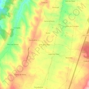
Name: Chão do Galego topographic map, elevation, terrain.
Location: Chão do Galego, Turquel, Alcobaça, Leiria, 2460-795, Portugal (39.46876 -8.97598 39.50876 -8.93598)
Average elevation: 168 m
Minimum elevation: 76 m
Maximum elevation: 243 m
Thank you for supporting this site ❤️
Make a donation
Make a donation
Other topographic maps
Click on a map to view its topography, its elevation and its terrain.