
Thank you for supporting this site ❤️
Make a donation
Make a donation
Gramado topographic map
Click on the map to display elevation.
Thank you for supporting this site ❤️
Make a donation
Make a donation
About this map
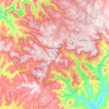
Name: Gramado topographic map, elevation, terrain.
Average elevation: 594 m
Minimum elevation: 55 m
Maximum elevation: 894 m
Thank you for supporting this site ❤️
Make a donation
Make a donation
Other topographic maps
Click on a map to view its topography, its elevation and its terrain.
Porto Alegre
Brazil > Rio Grande do Sul > Metropolitan Region of Porto Alegre > Porto Alegre
Porto Alegre has a long coastline on the Guaíba Lake, and its topography is punctuated by 40 hills. In the lake, a vast body of water, a maze of islands facing the city creates an archipelago where a unique ecosystem gives shelter to abundant wildlife. The city area concentrates 28% of the native flora of Rio…
Average elevation: 27 m
Praça Columia City/ Bom Fim
Brazil > Rio Grande do Sul > Metropolitan Region of Porto Alegre > Guaíba
Average elevation: 26 m