
Thank you for supporting this site ❤️
Make a donation
Make a donation
Alma topographic map
Click on the map to display elevation.
Thank you for supporting this site ❤️
Make a donation
Make a donation
About this map
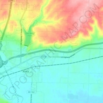
Name: Alma topographic map, elevation, terrain.
Location: Alma, Crawford County, Arkansas, United States (35.46290 -94.25433 35.52075 -94.16533)
Average elevation: 167 m
Minimum elevation: 117 m
Maximum elevation: 267 m
Thank you for supporting this site ❤️
Make a donation
Make a donation
Other topographic maps
Click on a map to view its topography, its elevation and its terrain.