
Thank you for supporting this site ❤️
Make a donation
Make a donation
Golden Valley topographic map
Click on the map to display elevation.
Thank you for supporting this site ❤️
Make a donation
Make a donation
About this map
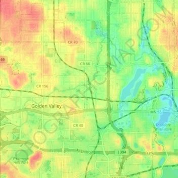
Name: Golden Valley topographic map, elevation, terrain.
Location: Golden Valley, Hennepin County, Minnesota, United States (44.96651 -93.40067 45.01693 -93.31845)
Average elevation: 276 m
Minimum elevation: 249 m
Maximum elevation: 300 m
Thank you for supporting this site ❤️
Make a donation
Make a donation
Other topographic maps
Click on a map to view its topography, its elevation and its terrain.
Minnehaha Regional Park
United States > Minnesota > Hennepin County > Minneapolis
Fortunately for the generations to come, in 1883 the state legislature created the Minneapolis Board of Park Commissioners. The board began by acquiring park land near today's downtown Minneapolis. Their choice to hire noted landscape architect Horace Cleveland was fortunate. Cleveland was hired by the Board…
Average elevation: 249 m