
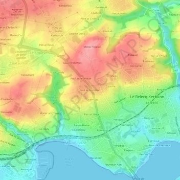
Poul ar Feunteun topographic map
Interactive map
Click on the map to display elevation.
About this map
Name: Poul ar Feunteun topographic map, elevation, terrain.
Average elevation: 49 m
Minimum elevation: -2 m
Maximum elevation: 106 m
Other topographic maps
Click on a map to view its topography, its elevation and its terrain.
Keroumen
France > Bretagne > Finistère > Le Relecq-Kerhuon
Keroumen, Le Relecq-Kerhuon, Brest, Finistère, Bretagne, France métropolitaine, 29480, France
Average elevation: 51 m
Keriézou
France > Bretagne > Finistère > Le Relecq-Kerhuon
Keriézou, Le Relecq-Kerhuon, Brest, Finistère, Bretagne, France métropolitaine, 29480, France
Average elevation: 30 m
Kergaret
France > Bretagne > Finistère > Le Relecq-Kerhuon
Kergaret, Le Relecq-Kerhuon, Brest, Finistère, Bretagne, France métropolitaine, 29480, France
Average elevation: 43 m
Baradozic
France > Bretagne > Finistère > Le Relecq-Kerhuon
Baradozic, Le Relecq-Kerhuon, Brest, Finistère, Bretagne, France métropolitaine, 29480, France
Average elevation: 29 m
Feunteun Aon
France > Bretagne > Finistère > Le Relecq-Kerhuon > Feunteun Aon
Feunteun Aon, Le Relecq-Kerhuon, Brest, Finistère, Bretagne, France métropolitaine, 29480, France
Average elevation: 29 m
Le Cosquer
France > Bretagne > Finistère > Le Relecq-Kerhuon
Le Cosquer, Le Relecq-Kerhuon, Brest, Finistère, Bretagne, France métropolitaine, 29480, France
Average elevation: 39 m
Rubian
France > Bretagne > Finistère > Le Relecq-Kerhuon
Rubian, Le Relecq-Kerhuon, Brest, Finistère, Bretagne, France métropolitaine, 29480, France
Average elevation: 33 m