
Jibhi topographic map
Interactive map
Click on the map to display elevation.
About this map
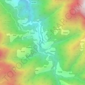
Name: Jibhi topographic map, elevation, terrain.
Location: Jibhi, Banjar, Kullu District, Himachal Pradesh, 175123, India (31.57228 77.33262 31.61228 77.37262)
Average elevation: 2,242 m
Minimum elevation: 1,565 m
Maximum elevation: 3,319 m
Other topographic maps
Click on a map to view its topography, its elevation and its terrain.
Manali
India > Himachal Pradesh > Banjar > Banjar
Manali, Banjar, Kullu District, Himachal Pradesh, 175123, India
Average elevation: 1,761 m
Giyagi
India > Himachal Pradesh > Banjar
Giyagi, Banjar, Kullu District, Himachal Pradesh, India
Average elevation: 2,341 m
Deotha
India > Himachal Pradesh > Banjar
Deotha, Banjar, Kullu District, Himachal Pradesh, 175123, India
Average elevation: 2,209 m
Pekhri
India > Himachal Pradesh > Banjar
Pekhri, Banjar, Kullu District, Himachal Pradesh, India
Average elevation: 2,192 m