
Thank you for supporting this site ❤️
Make a donation
Make a donation
Tuckerton topographic map
Click on the map to display elevation.
Thank you for supporting this site ❤️
Make a donation
Make a donation
About this map
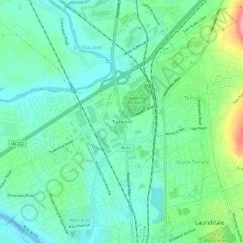
Name: Tuckerton topographic map, elevation, terrain.
Average elevation: 101 m
Minimum elevation: 67 m
Maximum elevation: 197 m
Thank you for supporting this site ❤️
Make a donation
Make a donation
Other topographic maps
Click on a map to view its topography, its elevation and its terrain.
Temple
United States > Pennsylvania > Berks County > Muhlenberg Township
Temple is a census-designated place in Muhlenberg Township, Berks County, Pennsylvania, United States at an elevation of 361 feet (110 m). The community was named for a local inn called Solomon's Temple. Temple was an independent borough until it was disincorporated on January 1, 1999. The ZIP code is 19560.…
Average elevation: 126 m
South Temple
United States > Pennsylvania > Berks County > Muhlenberg Township
Average elevation: 119 m