Geolocate

Rockford topographic map

Interactive map

Click on the map to display elevation.

About this map

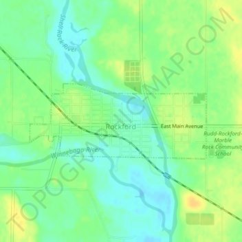
Name: Rockford topographic map, elevation, terrain.

Location: Rockford, Floyd County, Iowa, United States (43.04858 -92.96248 43.05698 -92.93548)

Average elevation: 311 m

Minimum elevation: 299 m

Maximum elevation: 324 m

Other topographic maps

Click on a map to view its topography, its elevation and its terrain.

Charles City

United States > Iowa > Floyd County

Charles City, Floyd County, Iowa, 50616, United States

Average elevation: 315 m

Marble Rock

United States > Iowa > Floyd County

Marble Rock, Floyd County, Iowa, 50653, United States

Average elevation: 308 m

Floyd

United States > Iowa > Floyd County

Floyd, Floyd County, Iowa, United States

Average elevation: 323 m

Colwell

United States > Iowa > Floyd County

Colwell, Floyd County, Iowa, United States

Average elevation: 343 m

Nora Springs

United States > Iowa > Floyd County

Nora Springs, Floyd County, Iowa, 50458, United States

Average elevation: 333 m

Rudd

United States > Iowa > Floyd County

Rudd, Floyd County, Iowa, United States

Average elevation: 339 m