
Thank you for supporting this site ❤️
Make a donation
Make a donation
Whiting topographic map
Click on the map to display elevation.
Thank you for supporting this site ❤️
Make a donation
Make a donation
About this map
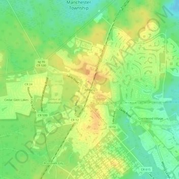
Name: Whiting topographic map, elevation, terrain.
Average elevation: 47 m
Minimum elevation: 30 m
Maximum elevation: 60 m
Thank you for supporting this site ❤️
Make a donation
Make a donation
Other topographic maps
Click on a map to view its topography, its elevation and its terrain.
Cedar Glen Lakes
United States > New Jersey > Ocean County > Manchester Township > Cedar Glen Lakes
Average elevation: 47 m
Cedar Glen West
United States > New Jersey > Ocean County > Manchester Township > Cedar Glen West
Average elevation: 24 m