
Alcedo topographic map
Interactive map
Click on the map to display elevation.
About this map
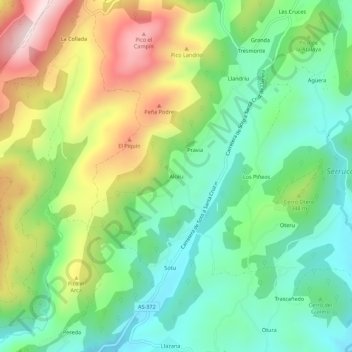
Name: Alcedo topographic map, elevation, terrain.
Location: Alcedo, Las Regueras, Asturias, 33190, España (43.41563 -6.00287 43.45563 -5.96287)
Average elevation: 292 m
Minimum elevation: 112 m
Maximum elevation: 604 m
Other topographic maps
Click on a map to view its topography, its elevation and its terrain.
Peña Prieta
España > Asturias > Las Regueras
Peña Prieta, Las Regueras, Asturias, 33190, España
Average elevation: 156 m
Las Regueras
España > Asturias > Las Regueras
Las Regueras, Asturias, 33190, España
Average elevation: 239 m
Laracha
España > Asturias > Las Regueras > Laracha
Laracha, Las Regueras, Asturias, 33820, España
Average elevation: 154 m