
Thank you for supporting this site ❤️
Make a donation
Make a donation
Hussein Dey topographic map
Click on the map to display elevation.
Thank you for supporting this site ❤️
Make a donation
Make a donation
About this map
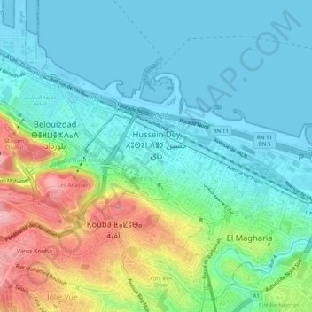
Name: Hussein Dey topographic map, elevation, terrain.
Location: Hussein Dey, Hussein Dey District, Algiers, Algeria (36.73005 3.08401 36.75298 3.13227)
Average elevation: 38 m
Minimum elevation: -3 m
Maximum elevation: 138 m
Thank you for supporting this site ❤️
Make a donation
Make a donation
Other topographic maps
Click on a map to view its topography, its elevation and its terrain.
El Magharia
Algeria > Algiers > Hussein Dey District > El Magharia > El Magharia
Average elevation: 30 m