
Three Bridges topographic map
Interactive map
Click on the map to display elevation.
About this map
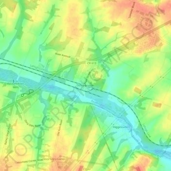
Name: Three Bridges topographic map, elevation, terrain.
Average elevation: 48 m
Minimum elevation: 23 m
Maximum elevation: 73 m
Other topographic maps
Click on a map to view its topography, its elevation and its terrain.
Darts Mills
United States > New Jersey > Hunterdon County > Readington Township
Darts Mills, Readington Township, Hunterdon County, New Jersey, 08822, United States
Average elevation: 49 m
Pleasant Run
United States > New Jersey > Hunterdon County > Readington Township
Pleasant Run, Readington Township, Hunterdon County, New Jersey, 08887, United States
Average elevation: 63 m
Centerville
United States > New Jersey > Hunterdon County > Readington Township
Centerville, Readington Township, Hunterdon County, New Jersey, 08853, United States
Average elevation: 49 m
Dreahook
United States > New Jersey > Hunterdon County > Readington Township
Dreahook, Readington Township, Hunterdon County, New Jersey, 08889, United States
Average elevation: 80 m
Potterstown
United States > New Jersey > Hunterdon County > Readington Township
Potterstown, Readington Township, Hunterdon County, New Jersey, 08833, United States
Average elevation: 83 m
Stanton
United States > New Jersey > Hunterdon County > Readington Township
Stanton, Readington Township, Hunterdon County, New Jersey, 08885, United States
Average elevation: 97 m
Riverside
United States > New Jersey > Hunterdon County > Readington Township
Riverside, Readington Township, Hunterdon County, New Jersey, 08887, United States
Average elevation: 46 m
Whitehouse Station
United States > New Jersey > Hunterdon County > Readington Township
Whitehouse Station, Readington Township, Hunterdon County, New Jersey, 08889, United States
Average elevation: 61 m