
Le Val topographic map
Interactive map
Click on the map to display elevation.
About this map
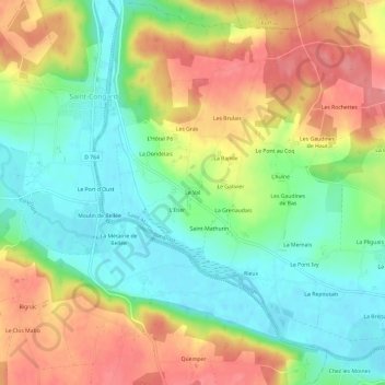
Name: Le Val topographic map, elevation, terrain.
Average elevation: 44 m
Minimum elevation: 4 m
Maximum elevation: 93 m
Other topographic maps
Click on a map to view its topography, its elevation and its terrain.
Le Guélin
France > Bretagne > Morbihan > Saint-Martin-sur-Oust
Le Guélin, Saint-Martin-sur-Oust, Vannes, Morbihan, Bretagne, France métropolitaine, 56200, France
Average elevation: 37 m