
Thank you for supporting this site ❤️
Make a donation
Make a donation
Swinton topographic map
Click on the map to display elevation.
Thank you for supporting this site ❤️
Make a donation
Make a donation
Swinton
Swinton lies at 53°30′44″N 2°20′28″W / 53.51222°N 2.34111°W / 53.51222; -2.34111 (53.5122°, -2.3412°), 167 miles (269 km) northwest of central London, and 4.2 miles (6.8 km) west-northwest of Manchester city centre. Topographically, Swinton occupies an area of gently sloping ground, roughly 213 feet (65 m) above sea level, and is on the south side of the River Irwell. Swinton lies in the west-central part of the Greater Manchester Urban Area, the UK's second largest conurbation. The M60 motorway passes Swinton on its northwest side.
Thank you for supporting this site ❤️
Make a donation
Make a donation
About this map
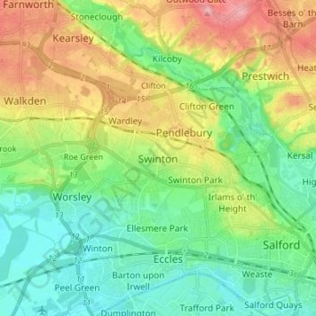
Name: Swinton topographic map, elevation, terrain.
Average elevation: 59 m
Minimum elevation: 17 m
Maximum elevation: 138 m
Thank you for supporting this site ❤️
Make a donation
Make a donation