
Thank you for supporting this site ❤️
Make a donation
Make a donation
Leverkusen topographic map
Click on the map to display elevation.
Thank you for supporting this site ❤️
Make a donation
Make a donation
About this map
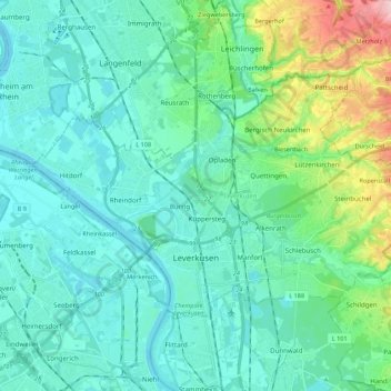
Name: Leverkusen topographic map, elevation, terrain.
Location: Leverkusen, North Rhine-Westphalia, Germany (51.01112 6.89783 51.09719 7.11608)
Average elevation: 68 m
Minimum elevation: 32 m
Maximum elevation: 230 m
Thank you for supporting this site ❤️
Make a donation
Make a donation
Other topographic maps
Click on a map to view its topography, its elevation and its terrain.
Thank you for supporting this site ❤️
Make a donation
Make a donation
Plettenburg
Germany > North Rhine-Westphalia > Rheinisch-Bergischer Kreis > Wermelskirchen > Grunewald
Average elevation: 231 m