
Make a donation
Sapporo topographic map
Click on the map to display elevation.
Make a donation
Sapporo
Sapporo is a city located in the southwest part of Ishikari Plain and the alluvial fan of the Toyohira River, a tributary stream of the Ishikari River. It is part of Ishikari Subprefecture. Roadways in the urban district are laid to make a grid plan. The western and southern parts of Sapporo are occupied by a number of mountains including Mount Teine, Maruyama, and Mount Moiwa, as well as many rivers including the Ishikari River, Toyohira River, and Sōsei River. Sapporo has an elevation of 29 m (95 ft 2 in).
Make a donation
About this map
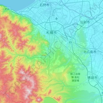
Name: Sapporo topographic map, elevation, terrain.
Location: Sapporo, Ishikari Subprefecture, Hokkaido Prefecture, Japan (42.78071 140.99050 43.18999 141.50542)
Average elevation: 273 m
Minimum elevation: -2 m
Maximum elevation: 1,299 m
Make a donation
Other topographic maps
Click on a map to view its topography, its elevation and its terrain.
Mt. Fuji
Japan > Sunto County > Oyama
Mount Fuji (富士山, Fujisan, Japanese: [ɸɯꜜ(d)ʑisaɴ] ) is an active stratovolcano located on the Japanese island of Honshu, with a summit elevation of 3,776.24 m (12,389 ft 3 in). It is the tallest mountain in Japan, the second-highest volcano located on an island in Asia (after Mount Kerinci on the…
Average elevation: 3,261 m
Make a donation