
Thank you for supporting this site ❤️
Make a donation
Make a donation
Malden topographic map
Click on the map to display elevation.
Thank you for supporting this site ❤️
Make a donation
Make a donation
Malden
Malden is bordered by Melrose on the north, Medford on the west, Everett on the south, Revere on the east, and Saugus on the northeast. Boojum Rock located in the north west corner of Malden inside the Middlesex Fells Reservation is the highest point in Malden with an elevation of approximately 275 feet.
Thank you for supporting this site ❤️
Make a donation
Make a donation
About this map
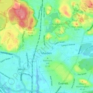
Name: Malden topographic map, elevation, terrain.
Location: Malden, Middlesex County, Massachusetts, United States (42.41255 -71.08945 42.44471 -71.02038)
Average elevation: 25 m
Minimum elevation: -2 m
Maximum elevation: 85 m
Thank you for supporting this site ❤️
Make a donation
Make a donation
Other topographic maps
Click on a map to view its topography, its elevation and its terrain.
Arlington Heights
United States > Massachusetts > Middlesex County > Arlington
Average elevation: 58 m