
Make a donation
Agualeguas topographic map
Click on the map to display elevation.
Make a donation
About this map
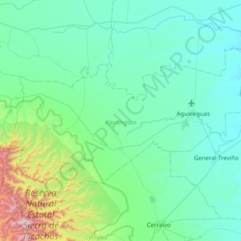
Name: Agualeguas topographic map, elevation, terrain.
Location: Agualeguas, Nuevo León, Mexico (26.15075 -99.95562 26.44603 -99.40973)
Average elevation: 306 m
Minimum elevation: 119 m
Maximum elevation: 1,520 m
Make a donation
Other topographic maps
Click on a map to view its topography, its elevation and its terrain.
Monterrey
Mexico > Nuevo León > Monterrey
The city of Monterrey is 540 metres (1,770 ft) above sea level in the northeastern state of Nuevo León. Monterrey translated literally from Spanish to English is "King Mount" or "King Mountain", and folk etymology claims that this refers to the city's topography and the large mountains that surround it…
Average elevation: 753 m
Monterrey
Mexico > Nuevo León > Monterrey
The city of Monterrey is 540 metres (1,770 ft) above sea level in the northeastern state of Nuevo León. Monterrey translated from Spanish to English is "King Mount" or "King mountain", which refers to the city's topography and the large mountains that surround it. The Santa Catarina River—dry most of the…
Average elevation: 753 m
Make a donation
Montemorelos
Mexico > Nuevo León > Montemorelos
In 1637, Governor Martín de Zavala promised a large tract of land in central Nuevo León to Captain Alonso de León on condition that, in less than a year, a colonial settlement is built and populated inside its borders. De León distributed the estate to his children and one of them, Alonso de León…
Average elevation: 418 m
Make a donation
Monterrey
Mexico > Nuevo León > Monterrey
The city of Monterrey is 540 metres (1,770 ft) above sea level in the northeastern state of Nuevo León. Monterrey translated literally from Spanish to English is "King Mount" or "King Mountain", and folk etymology claims that this refers to the city's topography and the large mountains that surround it…
Average elevation: 753 m
Parque recreativo presa de Mamulique
Mexico > Nuevo León > Salinas Victoria > Mamulique
Average elevation: 495 m
Make a donation
Monterrey
Mexico > Nuevo León > Monterrey
The city of Monterrey is 540 metres (1,770 ft) above sea level in the northeastern state of Nuevo León. Monterrey translated literally from Spanish to English is "King Mount" or "King Mountain", and folk etymology claims that this refers to the city's topography and the large mountains that surround it…
Average elevation: 753 m
Make a donation
National Park Summits of Monterrey
Mexico > Nuevo León > Santiago
The park is located in the northern portion of the Sierra Madre Oriental, which was formed by rock folding of marine based sedimentary strata during the Eocene epoch in the Laramide orogeny period. The marine sedimentary rock rose over the years to an elevation of 2,260 m (7,410 ft) above sea level. The…
Average elevation: 1,505 m
Make a donation
Montemorelos
Mexico > Nuevo León > Montemorelos
In 1637, Governor Martín de Zavala promised a large tract of land in central Nuevo León to Captain Alonso de León on condition that, in less than a year, a colonial settlement is built and populated inside its borders. De León distributed the estate to his children and one of them, Alonso de León…
Average elevation: 418 m
Make a donation
Monterrey
Mexico > Nuevo León > Monterrey
The city of Monterrey is 540 metres (1,770 ft) above sea level in the northeastern state of Nuevo León. Monterrey translated literally from Spanish to English is "King Mount" or "King Mountain", and folk etymology claims that this refers to the city's topography and the large mountains that surround it…
Average elevation: 753 m
Make a donation
Make a donation
Make a donation