
Thank you for supporting this site ❤️
Make a donation
Make a donation
Mageret topographic map
Click on the map to display elevation.
Thank you for supporting this site ❤️
Make a donation
Make a donation
About this map
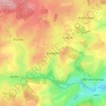
Name: Mageret topographic map, elevation, terrain.
Location: Mageret, Bastogne, Luxembourg, Wallonie, Belgique (49.99436 5.76503 50.03436 5.80503)
Average elevation: 480 m
Minimum elevation: 393 m
Maximum elevation: 555 m
Thank you for supporting this site ❤️
Make a donation
Make a donation
Other topographic maps
Click on a map to view its topography, its elevation and its terrain.