
Thank you for supporting this site ❤️
Make a donation
Make a donation
Arrifes topographic map
Click on the map to display elevation.
Thank you for supporting this site ❤️
Make a donation
Make a donation
About this map
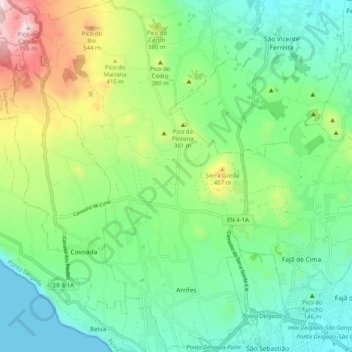
Name: Arrifes topographic map, elevation, terrain.
Location: Arrifes, Ponta Delgada, Açores, Portugal (37.74792 -25.74117 37.82798 -25.67550)
Average elevation: 241 m
Minimum elevation: 0 m
Maximum elevation: 817 m
Thank you for supporting this site ❤️
Make a donation
Make a donation
Other topographic maps
Click on a map to view its topography, its elevation and its terrain.