
Thank you for supporting this site ❤️
Make a donation
Make a donation
Pinetop topographic map
Click on the map to display elevation.
Thank you for supporting this site ❤️
Make a donation
Make a donation
About this map
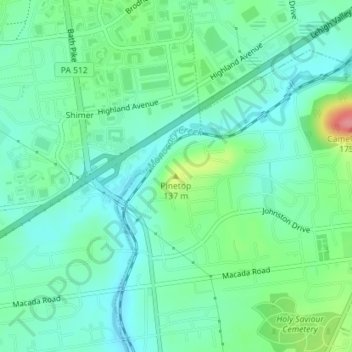
Name: Pinetop topographic map, elevation, terrain.
Average elevation: 108 m
Minimum elevation: 84 m
Maximum elevation: 175 m
Thank you for supporting this site ❤️
Make a donation
Make a donation
Other topographic maps
Click on a map to view its topography, its elevation and its terrain.
Illick's Mill Road Gateway
United States > Pennsylvania > Northampton County > Bethlehem
Average elevation: 105 m