
Thank you for supporting this site ❤️
Make a donation
Make a donation
Arona topographic map
Click on the map to display elevation.
Thank you for supporting this site ❤️
Make a donation
Make a donation
About this map
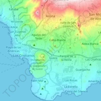
Name: Arona topographic map, elevation, terrain.
Location: Arona, Santa Cruz de Tenerife, Kanarische Inseln, Spanien (27.99808 -16.73730 28.11875 -16.63785)
Average elevation: 212 m
Minimum elevation: -2 m
Maximum elevation: 1,067 m
Thank you for supporting this site ❤️
Make a donation
Make a donation
Other topographic maps
Click on a map to view its topography, its elevation and its terrain.
Thank you for supporting this site ❤️
Make a donation
Make a donation
Thank you for supporting this site ❤️
Make a donation
Make a donation
Thank you for supporting this site ❤️
Make a donation
Make a donation