
Thank you for supporting this site ❤️
Make a donation
Make a donation
Vermilion Hill topographic map
Click on the map to display elevation.
Thank you for supporting this site ❤️
Make a donation
Make a donation
About this map
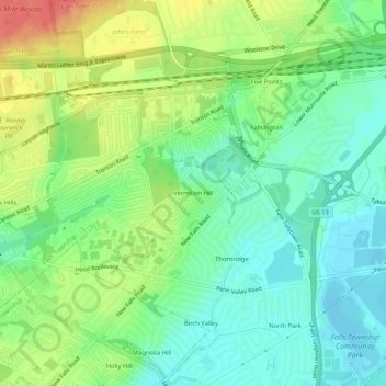
Name: Vermilion Hill topographic map, elevation, terrain.
Average elevation: 26 m
Minimum elevation: 5 m
Maximum elevation: 59 m
Thank you for supporting this site ❤️
Make a donation
Make a donation
Other topographic maps
Click on a map to view its topography, its elevation and its terrain.
Falls Township Community Park
United States > Pennsylvania > Bucks County > Falls Township > Wheat Sheaf
Average elevation: 9 m