
Thank you for supporting this site ❤️
Make a donation
Make a donation
Flavion topographic map
Click on the map to display elevation.
Thank you for supporting this site ❤️
Make a donation
Make a donation
About this map
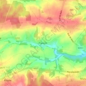
Name: Flavion topographic map, elevation, terrain.
Location: Flavion, Florennes, Philippeville, Namen, Wallonië, 5620, België (50.22963 4.69340 50.26963 4.73340)
Average elevation: 270 m
Minimum elevation: 227 m
Maximum elevation: 304 m
Thank you for supporting this site ❤️
Make a donation
Make a donation
Other topographic maps
Click on a map to view its topography, its elevation and its terrain.
Hemptinne
België > Namen > Philippeville > Florennes
De hoogte aan de kerk bedraagt 245 meter
Average elevation: 261 m