
Make a donation
Fletcher topographic map
Click on the map to display elevation.
Make a donation
Fletcher
Fletcher is located in southern Franklin County, bordered to the southeast by Lamoille County. According to the United States Census Bureau, the town has a total area of 38.0 square miles (98.4 km2), of which 37.7 square miles (97.7 km2) is land and 0.3 square miles (0.7 km2), or 0.71%, is water. The Lamoille River forms the short southern boundary of the town. Metcalf Pond is located in the north-central part of town. Fletcher Mountain, with a summit elevation of 2,150 feet (660 m), is located at the eastern end of town.
Make a donation
About this map
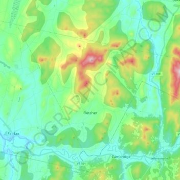
Name: Fletcher topographic map, elevation, terrain.
Location: Fletcher, Franklin County, Vermont, 05448, United States (44.64571 -73.00471 44.76055 -72.78366)
Average elevation: 229 m
Minimum elevation: 103 m
Maximum elevation: 610 m
Make a donation
Other topographic maps
Click on a map to view its topography, its elevation and its terrain.
Make a donation
Make a donation
Enosburg Center
United States > Vermont > Franklin County > Enosburg > Enosburg Center
Average elevation: 231 m