Geolocate

Floyd topographic map

Interactive map

Click on the map to display elevation.

About this map

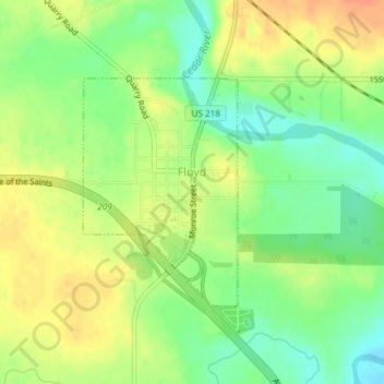
Name: Floyd topographic map, elevation, terrain.

Location: Floyd, Floyd County, Iowa, United States (43.11843 -92.74710 43.13446 -92.73218)

Average elevation: 323 m

Minimum elevation: 301 m

Maximum elevation: 345 m

Other topographic maps

Click on a map to view its topography, its elevation and its terrain.

Charles City

United States > Iowa > Floyd County

Charles City, Floyd County, Iowa, 50616, United States

Average elevation: 315 m

Marble Rock

United States > Iowa > Floyd County

Marble Rock, Floyd County, Iowa, 50653, United States

Average elevation: 308 m

Rockford

United States > Iowa > Floyd County

Rockford, Floyd County, Iowa, United States

Average elevation: 311 m

Colwell

United States > Iowa > Floyd County

Colwell, Floyd County, Iowa, United States

Average elevation: 343 m

Nora Springs

United States > Iowa > Floyd County

Nora Springs, Floyd County, Iowa, 50458, United States

Average elevation: 333 m

Rudd

United States > Iowa > Floyd County

Rudd, Floyd County, Iowa, United States

Average elevation: 339 m