
Lake Tahoe topographic map
Interactive map
Click on the map to display elevation.
About this map
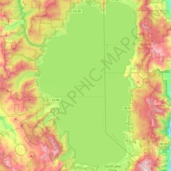
Name: Lake Tahoe topographic map, elevation, terrain.
Location: Lake Tahoe, Placer County, California, United States (38.92817 -120.16394 39.24901 -119.92606)
Average elevation: 2,077 m
Minimum elevation: 1,456 m
Maximum elevation: 2,965 m
Lake Tahoe has a dry-summer continental climate (Dsb in the Köppen climate classification), featuring warm, dry summers and chilly winters with regular snowfall. Mean annual precipitation ranges from over 55 inches (1440 mm) for watersheds on the west side of the basin to about 26 inches (660 mm) near the lake on the east side of the basin. Most of the precipitation falls as snow between November and April, although rainstorms combined with rapid snowmelt account for the largest floods. There is a pronounced annual runoff of snowmelt in late spring and early summer, the timing of which varies from year to year. In some years, summertime monsoon storms from the Great Basin bring intense rainfall, especially to high elevations on the northeast side of the basin.
Other topographic maps
Click on a map to view its topography, its elevation and its terrain.
Auburn
United States > California > Placer County
Auburn, Placer County, California, 95603, United States
Average elevation: 380 m
Rocklin
United States > California > Placer County
Rocklin, Placer County, California, United States
Average elevation: 95 m
Granite Bay
United States > California > Placer County
Granite Bay, Placer County, California, 95746, United States
Average elevation: 116 m
Roseville
United States > California > Placer County
Roseville, Placer County, California, United States
Average elevation: 61 m
Baxter
United States > California > Placer County
Baxter, Placer County, California, United States
Average elevation: 1,232 m
Sugar Pine Point
United States > California > Placer County
Sugar Pine Point, Placer County, California, United States
Average elevation: 1,737 m
Deer Lake
United States > California > Placer County
Deer Lake, Placer County, California, United States
Average elevation: 2,019 m
Foresthill
United States > California > Placer County
Foresthill, Placer County, California, 95631, United States
Average elevation: 859 m
Loomis
United States > California > Placer County
Loomis, Placer County, California, 95650, United States
Average elevation: 122 m
North Auburn
United States > California > Placer County
North Auburn, Placer County, California, 95603, United States
Average elevation: 443 m
Avery's Pond
United States > California > Placer County
Avery's Pond, Placer County, California, United States
Average elevation: 189 m
Colfax
United States > California > Placer County
Colfax, Placer County, California, United States
Average elevation: 685 m
Foresthill
United States > California > Placer County
Foresthill, Placer County, California, 95631, United States
Average elevation: 749 m
Gold Run
United States > California > Placer County
Gold Run, Placer County, California, 95717, United States
Average elevation: 930 m
The Cedars
United States > California > Placer County
The Cedars, Placer County, California, United States
Average elevation: 1,904 m
Cherry Point
United States > California > Placer County
Cherry Point, Placer County, California, United States
Average elevation: 1,802 m
Tahoe City
United States > California > Placer County
Tahoe City, Placer County, California, 96145, United States
Average elevation: 2,005 m
Donner Pass
United States > California > Placer County
Donner Pass, Placer County, CAL Fire Northern Region, California, 96162, United States
Average elevation: 2,164 m
Applegate
United States > California > Placer County
Applegate, Placer County, California, 95703, United States
Average elevation: 588 m
Olympic Valley
United States > California > Placer County > Olympic Valley
Olympic Valley, Placer County, California, 96146, United States
Average elevation: 2,102 m
Auburn Ravine
United States > California > Placer County > Auburn
Auburn Ravine, Auburn, Placer County, California, 95658, United States
Average elevation: 248 m
Carnelian Bay
United States > California > Placer County
Carnelian Bay, Placer County, California, 96140, United States
Average elevation: 1,977 m
Nyack
United States > California > Placer County
Nyack, Placer County, CAL Fire Northern Region, California, 95715, United States
Average elevation: 1,537 m
Weimar
United States > California > Placer County
Weimar, Placer County, California, 95736, United States
Average elevation: 662 m
Dollar Point
United States > California > Placer County
Dollar Point, Placer County, California, United States
Average elevation: 1,955 m
Elders Corner
United States > California > Placer County
Elders Corner, Placer County, California, 95602, United States
Average elevation: 417 m
Iowa Hill
United States > California > Placer County
Iowa Hill, Placer County, California, United States
Average elevation: 804 m
Olympic Valley
United States > California > Placer County
Olympic Valley, Placer County, California, 96146, United States
Average elevation: 2,082 m
Lincoln
United States > California > Placer County
Lincoln, Placer County, California, United States
Average elevation: 34 m
Tahoe Vista
United States > California > Placer County > Kings Beach
Tahoe Vista, Kings Beach, Placer County, California, 96148, United States
Average elevation: 2,025 m
Emigrant Gap
United States > California > Placer County
Emigrant Gap, Placer County, California, 95715, United States
Average elevation: 1,563 m
French Meadows Reservoir
United States > California > Placer County
French Meadows Reservoir, Placer County, California, United States
Average elevation: 1,781 m
Blue Canyon
United States > California > Placer County
Blue Canyon, Placer County, California, 95701, United States
Average elevation: 1,452 m
Lincoln
United States > California > Placer County
Lincoln, Placer County, California, 95648, United States
Average elevation: 60 m
Alpine Meadows
United States > California > Placer County
Alpine Meadows, Placer County, California, 96146, United States
Average elevation: 2,163 m
Natural Dam
United States > California > Placer County > Loomis
Natural Dam, Loomis, Placer County, California, 95677, United States
Average elevation: 104 m
Lincoln
United States > California > Placer County
Lincoln, Placer County, California, 95648, United States
Average elevation: 60 m
Penryn
United States > California > Placer County
Penryn, Placer County, California, 95663, United States
Average elevation: 182 m
Snakehead Point
United States > California > Placer County
Snakehead Point, Placer County, California, United States
Average elevation: 817 m
Newcastle
United States > California > Placer County
Newcastle, Placer County, California, 95658, United States
Average elevation: 256 m
Meadow Vista
United States > California > Placer County
Meadow Vista, Placer County, California, 95722, United States
Average elevation: 544 m
Kings Beach
United States > California > Placer County
Kings Beach, Placer County, California, 96143, United States
Average elevation: 1,955 m
Cisco
United States > California > Placer County
Cisco, Placer County, California, 95278, United States
Average elevation: 1,857 m