
Triftgletscher topographic map
Interactive map
Click on the map to display elevation.
About this map
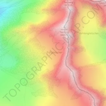
Name: Triftgletscher topographic map, elevation, terrain.
Average elevation: 2,870 m
Minimum elevation: 2,143 m
Maximum elevation: 3,422 m
Other topographic maps
Click on a map to view its topography, its elevation and its terrain.
Gauligletscher
Schweiz > Bern > Innertkirchen
Gauligletscher, Innertkirchen, Verwaltungskreis Interlaken-Oberhasli, Verwaltungsregion Oberland, Bern, 3862, Schweiz
Average elevation: 3,032 m
Glogghüs
Schweiz > Bern > Innertkirchen
Glogghüs, Innertkirchen, Verwaltungskreis Interlaken-Oberhasli, Verwaltungsregion Oberland, Bern, 3862, Schweiz
Average elevation: 1,563 m
Titlis
Schweiz > Bern > Innertkirchen
Titlis, Innertkirchen, Verwaltungskreis Interlaken-Oberhasli, Verwaltungsregion Oberland, Bern, 3862, Schweiz
Average elevation: 2,520 m