
Thank you for supporting this site ❤️
Make a donation
Make a donation
Abbots Langley topographic map
Click on the map to display elevation.
Thank you for supporting this site ❤️
Make a donation
Make a donation
About this map
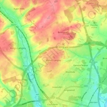
Name: Abbots Langley topographic map, elevation, terrain.
Average elevation: 102 m
Minimum elevation: 55 m
Maximum elevation: 147 m
Thank you for supporting this site ❤️
Make a donation
Make a donation
Other topographic maps
Click on a map to view its topography, its elevation and its terrain.
Primrosehill
United Kingdom > England > Hertfordshire > Three Rivers > Abbots Langley
Average elevation: 111 m
Pimlico
United Kingdom > England > Hertfordshire > Three Rivers > Abbots Langley
Average elevation: 123 m
The Rookery
United Kingdom > England > Hertfordshire > Three Rivers > Abbots Langley > Langleybury
Average elevation: 92 m
Thank you for supporting this site ❤️
Make a donation
Make a donation
Sarratt Bottom
United Kingdom > England > Hertfordshire > Three Rivers > Sarratt
Average elevation: 112 m
Oxhey Woods Local Nature Reserve
United Kingdom > England > Hertfordshire > Three Rivers > South Oxhey
Average elevation: 88 m
Thank you for supporting this site ❤️
Make a donation
Make a donation